Sunday, September 28, 2014

And so it ends...

I wasn't able to post last evening, because we were in Sisters again. The park is stunning and so handy to downtown, but alas, there is no wi-fi.  So, I will try to bring you up to date.

Yesterday was our last day at Crystal Crane Hot Springs.  We arose to cloudy skies, which kind of matched our mood about leaving this incredible place.  We had our coffee and took the girls out for a walk.  That was followed by our daily Bible reading.  At last, it was time to take a soak.  We walked over to the spring and waded in.  The water was not as hot as it had been the night before. Nevertheless, it was a pleasant soak. We met a couple from Pennsylvania who were about to head for home so they could be ready to go to Florida and prepare their rental property for the next renter. Then they will be off to somewhere (I forget) in their motor home. I felt really sorry for them.

We had a lovely chat about kids and grandkids and military service (he was a Marine; I was Navy), and then it was time to go. We returned to Topper and made final preparations for leaving. We were only about 6 minutes past check out time when we got away.

The drive to Sisters was "interesting."   We stopped in Burns for gas. Then we headed west on Hwy 20.  I have mentioned the wind in this area of the state. Well, it was blowing an estimated 15-20 MPH directly in our face for 90% of the drive. At times I wondered if Topper and Red Ryder were going to part company (adding our average speed of 55 to the 15-20, perhaps, you can understand my concern).

The other thing that made the drive "interesting" was that the terrain is so incredibly "the same."  For miles and miles we saw sage brush and other high desert plants and not much else.  There is an eerie beauty about the landscape, but it is, nonetheless, what I would call desolate. The drizzle of occasional rain showers helped to increase that perception, I think.


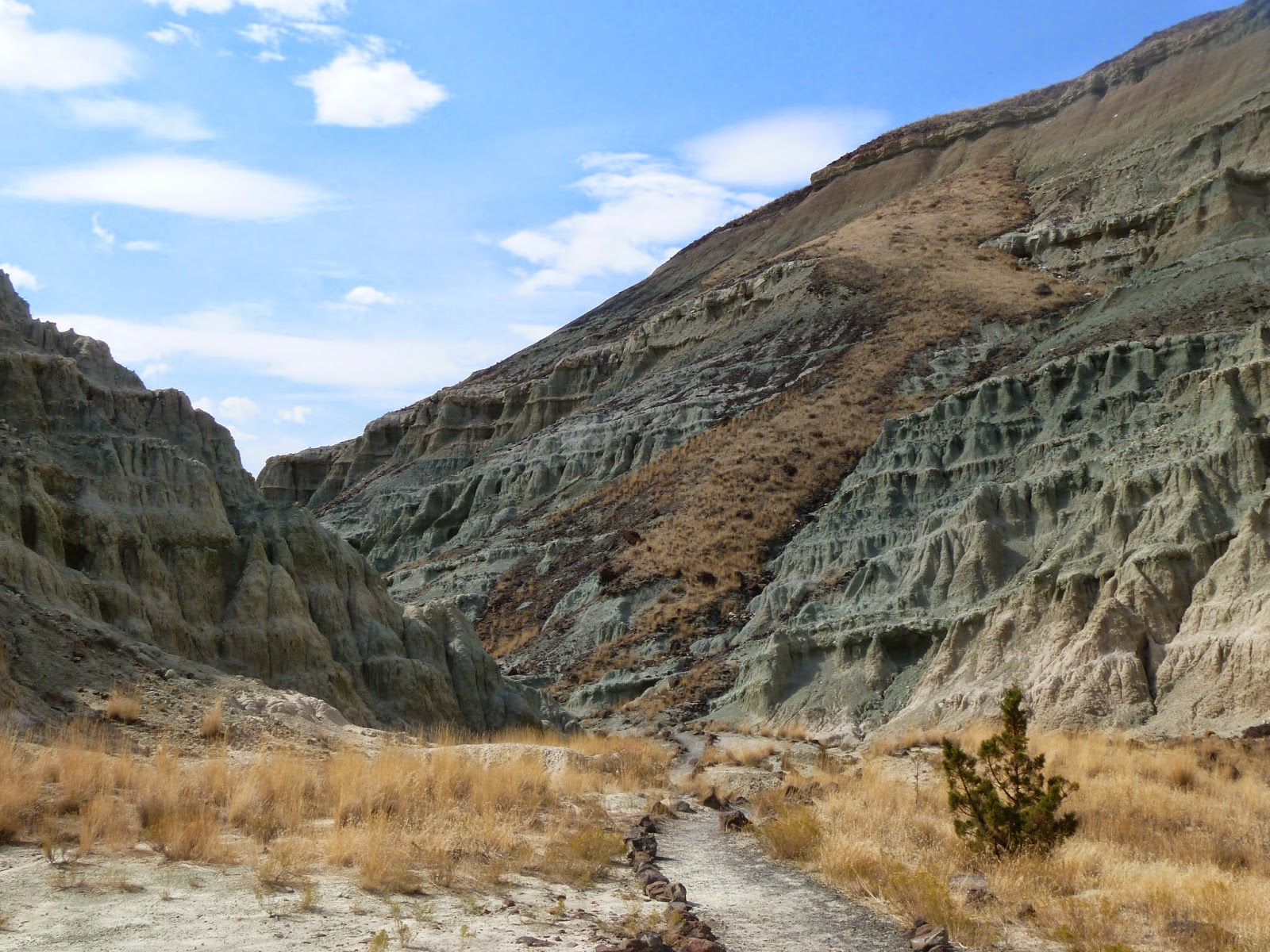
There were some fun features about the landscape, too.  Jill spotted this canyon or arroyo or whatever the proper term is. It was deeper than it looks and quite seemed like the work of some gigantic cosmic plow. 

At last, we began to descend.  The elevation had been pretty constant at around 4,100 feet.  Then we came over a hill and started down.  The landscape began to change rather abruptly.  


By the time we arrived in Sisters, the sky was partly cloudy; there were trees; the temperature was in the upper 60s; and we enjoyed seeing some sunshine. 

Our first order of business was to determine whether the Sisters Bakery would be open this morning, Sunday.  If not, we were prepared to buy our bear claws on the spot and save them for morning.  It turns out they are open at 5AM  on Sunday!

We walked over to the Three Creeks Brewing Co. for an early dinner.  Sisters is such a charming town and the Pub is equally so.  It is family friendly and exudes what I call "Mountain Culture." We had a delicious dinner at what we considered to be a very reasonable price.  When we were finished, we walked back to the park where Topper (and Lulu and Pogo) were awaiting our return.

The dogs were ready for their evening constitutional, so we took them for a long walk in the park.  When we returned to Topper, we were tired and decided to watch a movie.  I hadn't bothered to put up the TV antenna, so we popped a DVD in the machine and settled in to watch Mr. Smith once again taking on the graft and corruption in Washington.  He always wins, and as Jill commented during the film, "Everyone should watch this movie once in a while."

This morning we found sunshine awaiting us, although the temperature was just under 50 degrees.  After our morning reading and coffee, we walked over to the bakery and picked up the last two bear claws in the place. Whew! From there it was a short hike to the Sisters Coffee Company, where we shared a large vanilla latte, checked email and reveled in our bear claws.

After a stop at the local Ace Hardware (Jill's favorite place to visit in any town), we strolled hand-in-hand back to Topper and the girls.  It didn't take long for us to make final preparations to leave.  But not before we spoke with the gent next door about his lovely little motor home. I asked him how long it is, and he replied that he was not sure. A FRIEND HAD LOANED IT TO HIM!  He said it is brand new (no, duh!) and has only 2,800 miles on the odometer.  I asked if he would introduce me to his friend!

At last we left the park and made a stop at the gas station.  Then we headed west on Hwy 20. What a difference, compared to yesterday.   There was no wind, the road went up and down as well as left and right.  There were multiple species of evergreens to admire, and the sun was out. We climbed to the summit (about 4,800 ft. as I recall) and then started down the west side of the Cascade Range.

At some time in the past, there was an extensive burn in this area.  It was important enough that there is an interpretive center dedicated to it. We didn't stop, but we were awed by how much timber burned...and by the capricious way in which the fire had apparently just skipped over certain trees.


The Ponderosa Pine forests of Central Oregon, with their sparse undergrowth giving the feeling you could stop anywhere and camp,  gave way to the more familiar mixed conifers and deciduous trees of the rain forests, with their dense undergrowth, on the west slope.

We passed by Detroit Lake, which is always beautiful, and made a mental note to plan another camping trip there in the spring.

As we neared Dallas, and home, we were greeted by clear, blue skies and temperatures in the seventies.  Although we were sad that our vacation trip was over, we felt completely blessed to live in such a beautiful valley.

When we got Topper and Red Ryder safely tucked away in the garage and unloaded all the vacation gear, laundry, etc., we were treated to a neatly manicured lawn (thank you TJ) and a neat and tidy home inside (thank you, daughter Tara).  As Jill always says, "It's hard to end a wonderful vacation, but we have such a lovely home to come home to, that it makes it all OK."  We are so grateful to be blessed beyond measure by our Lord above.

Friday, September 26, 2014

What a time we had, Rosie Old Girl!

 Today, we decided to do some exploring. We weren't sure what to expect, because this part of Oregon is like a foreign country to us. Nevertheless, we had heard that the Malheur National Wildlife Refuge was a must see.  So, after a leisurely breakfast and a soak in the hot spring, we piled into Red Ryder and off we went to find the refuge. 

Now, I never claimed to be good at planning trips, so there were a few things I forgot:  1) to program the GPS (affectionately known as "Gerty," in phrases like, "Shut up, Gerty;" and "You screwed up, Gerty.") 2) To bring the binoculars, 3) To bring the map.  Otherwise, we were fully prepared. 

As we confidently drove along Princeton-Narrows Road, we came to a sign that said, "Malheur National Wildlife Refuge - Visitors' Center 13 miles."  "Good, we're on the right track," I said, as I proceeded to turn with the paved road.  It was about six miles later that I realized we should have gone straight onto the gravel road.

We found a place to turn around and headed back the way we came.  Finally, on the correct road, we found the Visitors' Center.  It was closed for lunch. If you have been following this trip with us, you will recognize a theme here.

We looked around and went up to the overlook.  There we saw the wide open spaces of the refuge looking to the east and the north toward Malheur Lake. 

 Here we are looking East. The dark line at the foot of the hills is the water of 
Malheur lake.  When it is filled with water, the lake extends much closer to our
vantage point. 

 This view is looking north. Again the water is the dark 
line, which is much receded from its banks.


We went back and waited for someone to show up at the Visitors' Center, but no joy.  So, we decided to press on.  Back in Red Ryder, we headed west on Sodhouse Rd. toward Narrows.  Narrows is at the junction of Sodhouse Rd. and Hwy 205.  It comprises a grocery story, cafe and gift shop.  Our new destination was the Buena Vista overlook, another section of the refuge. 

After a lovely drive, we found another overlook that provided some very nice views.

 Here is one of the Buena Vista ponds, which are filled year round and 
provide habitat for birds, deer, and other wild life.

 Here's part of what we saw along the highway.

 Looking southeast from Buena Vista, the mountain "range" on the horizon, 
is actually one mountain called Steens Mountain. 
At about 50 miles long it is essentially a monolith pushed up by seismic activity.

 If you click on the picture above, you can see some of the wildlife (birds) in this pond. 
Tom forgot the binoculars, so they could be egrets, swans, geese, or wads of discarded newspaper. 

 Another view of the wildlife ponds. 

 This is one of natures most beautiful formations. Oh, yeah. The rocks are nice, too.

 Did you ever see fluffier clouds?

 Our photography just doesn't do justice to the subtle pastels we saw looking across the plains.

When we left Buena Vista, we headed southeast toward Diamond. We had no idea what we might see. Well, the name of the road should have been a clue "Lava Beds Rd." Ya thank?? We passed through another national monument called Diamond Craters. The photo above is a mound that appears to have been lifted by volcanic forces and then as it cooled, it apparently cracked open .  There were lots of these things.

 Here is what appears to be a lava crust about 25 feet thick.  This must have been 
some kind of a hot bed (you should pardon the pun) of volcanic exuberance.

 Another lava topped hill.  Erosion has apparently removed the 
surrounding ground like a bas-relief carving.

Jill simply calls this one "Big Sky."

  
OK. So, another serendipitous find was the Peter French Round Barn. This baby is a marvel of ingenuity.  

Peter French at age 23 left California with 1,200 head of cattle, a cook and half a dozen hired cowboys.  They drove the cattle north to the (are you ready for the name of this river valley?) "Donner und Blitzen River!" They began ranching and eventually, according to the signage, "part" of French's ranch included the 200,000 acres that are visible from the vicinity of this barn.  

In order to manage all the cattle on the ranch, French and his men trained dozens of horses.  They kept them in several round barns, like the one pictured above.  The genius of these barns is that each one was made of stone walls made in a circle.  Outside of the stone wall was wooden wall, leaving a 20 foot wide paddock, where the horses could be run round and round for exercise and training. 


Here is a view of the "track" around the inner stone wall. 

Here is a picture of the center pole that holds up the roof.

We headed back to the Hot Springs. It was one of those days that always reminds me of a line that Humphrey Bogart spoke to Kathryn Hepburn in the movie "The African Queen."  After they had successfully navigated their 30' steamboat over several rapids and a waterfall, they found a quiet backwater,  where they tied up for the night. Kate looked on demurely as rough and rugged Bogie said, "What a time we had, Rosie old girl! What a time." 


Thursday, September 25, 2014

All's well that ends well

Here we are at Crystal Crane Hot Springs.  What a treat. We had a new RVing experience today.  We discovered after we arrived here that there is no laundry facility for guests. So, today we unloaded Topper and drove Red Ryder into Burns. We did some shopping and went to the laundromat.  More specifically, we went to Jiffy Wash.  Laundromats have come a long way. We did a load of wash in 29 minutes and dried it in 28 minutes! Hardly time to really get into some reading material. No, this wasn't our new experience...

When we returned to Topper, in a heavy wind with driven rain, we discovered that the power had failed in the park.  That hasn't happened to us before.  We began making plans for conserving energy, but I assured Jill that with water and sewer hook-up and plenty of propane, we merely need to conserve battery power.  That was before I used the bathroom and found that there was no water for flushing.  Apparently, the park's water is well water that requires a pump.

God was kind, though, and we were without power for about an hour and half. It went off for about five minutes again later, but now we have had continuous power for several hours. I took the precaution of putting some water in the fresh water tank, just in case the AC power goes off. We can still flush with the fresh water and our pump.

OK, so that was the big excitement. The trip to Burns was fairly non-interesting, but we do have enough clean clothes to get home. 

Meanwhile, here are some shots taken at the park.  It is in the desert (or semi-desert), so there are few trees.  Nevertheless there is an awesome beauty about this place, especially when the light is at a sharp angle, like at sunset or sunrise.

 Here we are looking across the park from our campsite, last evening. The teepee is just one
of the many options for staying here. There are motel rooms, dry camp sites and full hookups. 

 This is a similar view taken just before sundown today looking east. 

 And about the same time looking west. 

I will try to upload some more photos tomorrow, but the bandwidth is just too little right now. 

We enjoyed two soaks in the hot springs today.  The first was this morning. The sun was out and the wind was fairly calm. It was lovely.  This afternoon, after our power outage, we decided to soak again.  Our campsite is about a hundred yards from the hot spring. The wind was blowing and the temperature was about 54 degrees.  Having had no heat in the camper because of the power outage, we looked forward to warming up in the spring. 

Well, sometimes what you expect and what happens are not in sync, if you know what I mean.  Being concerned about the security of our jackets and towels, I carefully stacked them so that the wind would not move them. We walked into the spring and were happy to immerse ourselves in the warm water...which wasn't quite as warm with cloudy skies and wind as it had been in the morning sunshine. 

We moved around, getting ever closer to the hot water inlet until we found just the right temperature. Just as we found the perfect spot, a big gust of wind blew my towel and both of our jackets into  the water.  The towel nearly sank. The jackets floated, but got plenty wet.  

Now our campsite is upwind from the spring, so the trek home was into the wind (mind you it was 54 degrees, wind about 15 mph) wrapped in sodden jackets carrying a wet towel that probably weighed in at 7 lbs.! Can you say, "Freezing?"

We got home, slipped into sweat clothes and turned the heater on.  It took awhile, but we finally warmed up about dinner time.  All's well that ends well.


Wednesday, September 24, 2014

Here we go again...

Today was moving day. We thoroughly enjoyed our stay at Dayville.  The John Day valley and the fossil beds and attendant geology were thrilling to see.  We will likely return.  Today, however, we moved on to our next adventure.

We left Dayville about 11 AM and headed east to the city of John Day. It is charming.  We had been advised not to miss the "Chinese Museum" which is actually a state heritage site, commemorating Kam Wah Chung, a Chinese immigrant in the 19th century.  We arrived, of course, just in time for their lunch hour, so we wandered through the exhibit in the lobby for about 10 minutes until they closed for lunch.

What we learned was that in the 19th century, many Chinese left their home country and came to the west coast of the U.S. because of famine in China. They were drawn to the gold fields in the John Day area and worked alongside the U.S. miners, as well as providing services such as laundry, barbering, etc.

When the gold ran out, jobs became scarce, and the whites resented the Chinese, whom they blamed for the shortage of jobs, since the Chinese were generally paid at about half wage of whites. Violence broke out in many places where Chinese were living.  Eventually, the Federal Government passed a Chinese Exclusion Act.  Chinese were literally excluded by law from participating in many everyday activities vital to living.

Kam Wah Chung, as I understand it, provided a kind of sanctuary for Chinese in John Day. Here the Chinese in the area could get food and lodging, practice their religion and generally feel safe from the attacks of whites in the area.  I would tell you more, but we decided rather than to wait an hour for the tour, we would press on toward Burns, our destination for the day. Besides, now we have a stellar reason for returning to John Day.

As we headed south from John Day on US 395, we passed through Canyon City, which was one of the early centers of the mining trade. The Canyon from which it takes its name is beautiful. The road winds lazily up from John Day, following a creek (whose name I either didn't get or don't recall).


We were a little surprised to see dense evergreen forests along the way. They included pines, cedars, firs and even what appeared to be redwoods. The road continues to climb to just over 5,000 feet elevation, then, just as you are expecting to head down the backside of the mountain, you discover that after a modest descent of 4-500 feet, the terrain levels off into a plain. 

We crossed quite a broad expanse of grassy and sagebrush covered plain. This photo was taken at an elevation of 4,750 feet!  Eventually we came to the town of Seneca, which is quite a nice little settlement. 

We saw some beautiful rocks and trees and followed the Sylvies river for quite a spell.   

Past Seneca, the road rises again, this time topping 5,300 feet elevation. From there we drove through plains and hills, most of which seem to be part of the Sylvies Valley Ranch. It goes for miles and miles.

Finally, we arrived in Burns. A substantial city, Burns is the county seat of Harney County.  We stopped for gas and then headed SE toward Crane.  Just a few miles outside of Crane, we arrived at the Crystal Crane Hot Springs RV Park.

We haven't had time to explore the park fully, nor to use the hot spring yet.  It is windy, with gusts into the 20+ mph range. The landscape is flat and arid. But more about that in my next post!!

Monday, September 22, 2014

Howdy from Dayville

Howdy, again, from Dayville, OR!  We didn't spend much time in Dayville today, although below you will see the promised photos of the Fish House Inn and RV Park.

 Looking from the exit into the RV park. Notice 
Topper and Red Ryder on the left under the tree.

 The building in the foreground is the office, 
and the red building is the utility barn. 

Looking back into the park from the huge expanse of lawn.

This morning, we unloaded Topper from Red Ryder. That makes sightseeing ever so much easier.  We left the park and headed west on Hwy 26 toward picture gorge, a narrow winding gorge through which Rattlesnake Creek (don't you love that name?) runs. The gorge features 15 layers of basalt that were laid down during an era of "basalt flooding" when the earth opened up and poured forth magma. But more about that later.  

Before we got to the gorge, we turned off the road to see the Mascall Overlook.  This is a plateau that gives an elevated view of some of the fossil fields in the area. 


Looking East from the Overlook.

Looking west. Notice the striped rock below. This is an exposed area
of layer upon layer of volcanic ash that buried some of the creatures that became fossils.
 
The very flat tops on these hills are volcanic deposits over the 
top of volcanic ash and other sedimentary layers. 

The dark area in the center between the hills is Picture Gorge. 

On the way to the Gorge, we drove along Rattlesnake Creek. Notice the layering of the basalt.

We arrived at the Thomas Condon Paleontology Center. 

The Condon Paleontology Center is named for a clergyman from The Dalles who was also an amateur geologist.  He was the first to realize the importance of what later became known as the John Day Fossil Beds.  There is a statement attributed to him on one of the signs in the Center that says something like, 'The same God Who made all of this is the One Who made the hills around Jerusalem.' He goes on to say that the church has nothing to fear from the truth of creation being exposed.  Unfortunately, the Center seems to have rejected Condon's creationist viewpoint and is heavily rooted in the Evolutionist/Old Earth propaganda that is so widespread in our government institutions of learning. 

This is Sheep Rock, so named for the myriad sheep that used to 
roam this area when the settlers set about sheep farming.  

The John Day Fossil Beds National Monument exists as three "campuses," if you will: The Sheep Rock Unit, The Painted Hills Unit, and The Clarno Unit.  We obviously visited the Sheep Rock Unit. That is where the Condon Center is located. Part of the Sheep Rock Unit includes the Blue Basin area, which is a natural formation made up of layers of volcanic ash, in which are buried thousands of fossilized animals and plants. 

Looking back down the road from the parking lot of the Blue Basin Area.

There is a trail that circumnavigates the basin. Another trail leads directly into a natural "amphitheater" carved out of the rock. Since it was shorter, we took the latter trail. The path follows a creek bed that obviously has water in it at times, but it was bone dry today.  The colors of the rocks are incredible and impossible to capture on film. 


Along the trail, you can begin to see the blue-green rock that gives the basin its name.

The blue-green material looks very much like the volcanic ash I remember sweeping up after the 1980 Mt. St. Helens eruption, only it is compacted into solid layers. The creek bed is covered with powdery residue of this material.  The compacted material, though hard to the touch is quite friable, which is probably why it is so easy to find the fossils buried in it. It simply chips away, almost with finger pressure. My conclusion was that, in spite of the claims that it is 29 million years old, anything that friable would have washed away long before now, if it had really been there that long. 

I found the most beautiful blue flower along the path.

Here we are beginning to enter the amphitheater area.

Standing in the observation area in the center of the amphitheater, 
I turned around and took three pictures moving from right to left. 
The sequence begins with this shot and includes the next two photos.


As I mentioned, it is impossible to fully capture the beauty and grandeur of this place on film. I suggest you click on the photos to enlarge them. It may help to enhance my meager photographic efforts.

We left the Blue Basin Area and headed further north on Hwy 19.  There is one more section to the Sheep Rock Unit. It is called the Foree Area.  It includes a small picnic ground and a couple of short (1/4 mile) trails.  We stopped in the parking lot and could see that the paths lead to more of the incredible blue stones.  It was warm, so we decided to move on. 

Continuing north we followed the John Day River through a beautiful valley containing ranches and farms and bracketed by the breathtaking hills with their blues and reds and golds provided by various kinds of rock.  Eventually, we arrived at Kimberly, a "town" that once was thriving but now appears to comprise a Post Office/Store and an office building for the gigantic Longview Ranch, which we passed in the valley. Oh, yes, Kimberly sits at the junction of the main and north forks of the John Day river and the junction of Hwy 19 and Hwy 402, which goes east to Monument and Long Creek.

On our way back to Dayville, we passed Cathedral Rock. It is breathtaking in person.

Our evening brought a surprise thunderstorm that had our main dog, Pogo, panting and drooling from fright, while our small, auxiliary dog, Lulu, snoozed on the couch.  Gotta love your kids and their different personalities!